 NERC Data Catalogue Service
Ground water level
Type of resources
Topics
Keywords
Contact for the resource
Provided by
Years
Formats
Representation types
Update frequencies
-
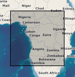
Multi-decadal time series of groundwater levels were compiled by the authors from records of observation wells initiated and maintained by government departments and research institutions in nine countries in sub-Saharan Africa. The pan-African collation of these hydrographs was initiated at the 41st Congress of the International Association of Hydrogeologists (IAH) in Marrakech (Morocco) on 14th September 2014. All records were subjected to a rigorous review by the authors during which the integrity, continuity, duration and interpretability of records were evaluated. This process included dedicated workshops in Benin, Tanzania, and Uganda, and records failing these tests were discarded from the analysis. Procedures included taking of the first time derivative to identify anomalous spikes in records commonly associated with errors of data-entry. Where multiple records in same geographic and climate zone were available (e.g. Benin, South Africa) we prioritized records remote from potential areas of intensive abstraction. Statistical clustering of records was also used in the Limpopo Basin of South Africa to identify the representativity of employed records at Modderfontein and Sterkloop.
-

Groundwater level measurements collected by the state groundwater boards of Punjab and Haryana states, India, and by the Central Groundwater Board. The data consist of well locations and measurements of groundwater levels, in metres below the top of the well casing. Data were collected in both the pre-monsoon (May-June) and post-monsoon (October-November) periods. Data availability is irregular across the entire suite of wells.
-
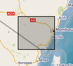
The dataset contains hourly river water level data for 3 monitoring sites; Mukurumudzi River (3KD06 Shimba Hills & KISCOL Weir) Ramisi River (Eshu Bridge) in Kwale County, Kenya
-

The file contain groundwater level/depth (WL), Groundwater and Surface Water Quality data (EC (micro-siemens per centimetre or µS/cm), Temperature (degrees C) and pH) for 49 points under fortnightly monitoring relevant to Gro for GooD research project in Kwale County, Kenya. Blank - Data not available. Note this is same dataset as NGDC record number 118189 with extended time series. Gro for GooD: Groundwater Risk Management for Growth and Development
-
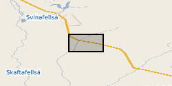
Groundwater level and groundwater temperature data measured in 9 boreholes between August 2012 and August 2018. Groundwater conductivity data measured in 1 of these boreholes from September 2012 to August 2014. Eight of the boreholes are drilled into a sandur (glacial outwash floodplain) aquifer in front of Virkisjokull glacier, SE Iceland, and are between 8.2 and 14.9 m deep. The remaining borehole is drilled into a volcanic rock aquifer between the sandur and glacier and is 5.1 m deep. Selected groundwater monitoring data are reported in Ó Dochartaigh, B. É., et al. 2019. Groundwater?- glacier?meltwater interaction in proglacial aquifers, Hydrol. Earth Syst. Sci. https://doi.org/10.5194/hess-2019-120. Further information on borehole installations and geology can be found in Ó Dochartaigh et al. 2012. Groundwater investigations at Virkisjokull, Iceland: data report 2012. British Geological Survey Open Report OR/12/088, http://nora.nerc.ac.uk/id/eprint/500570/